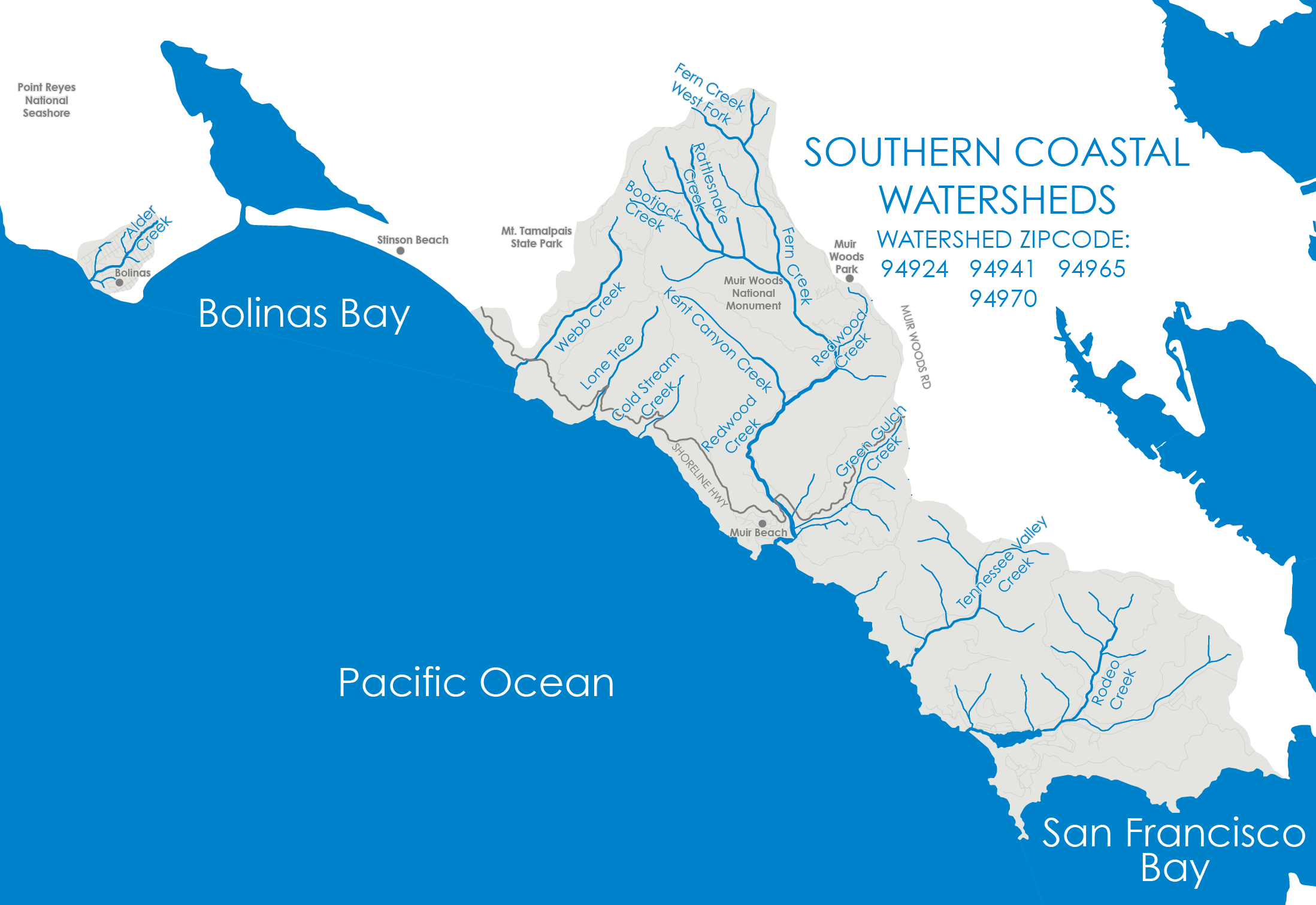
Your Southern Coastal Watersheds
The Southern Coastal Watersheds cover an area of more than 21 square miles are made up of seven coastal watersheds ranging from the Alder Creek Watershed on the Bolinas Mesa down to the Rodeo Creek Watershed ending at the Golden Gate Bridge.
Alder Creek
Alder Creek drains the western half of the Bolinas Mesa. This small, isolated watershed which includes most of the community of Bolinas is surrounded by the Point Reyes National Seashore Watershed to the north and the Bolinas Lagoon Watershed to the south and east. The creek flows into Duxbury Reef and the Pacific Ocean through Agate Beach. Agate Beach is a popular tidepooling spot open to the public and can be accessed by an easy, short path from the parking lot at Marin County’s Agate Beach Park. Alder Creek is an intermittent stream that typically goes dry from April to November.

The watershed is predominantly composed of residential and rural residential development. Many residents have small numbers of livestock on their property. A few commercial gardens and other small businesses, and portions of livestock ranches, also occur in the Alder Creek watershed. Undeveloped areas are primarily annual grassland and coastal scrub, with small groves of eucalyptus and Monterey pine. Monarch butterflies have been observed roosting in the eucalyptus trees.
The shoreline throughout the watershed is part of the Duxbury Reef Area of Special Biological Significance (ASBS). Duxbury Reef is considered the largest shale reef in North America. It provides an extensive system of rocky intertidal and subtidal habitat that supports large areas of kelp beds and is an important haul-out site for harbor seals. In addition, six species of algae and marine vascular plants, and 89 species of invertebrates, have been identified at Duxbury Reef. No fish have been observed in the seasonal drainages of the Bolinas Mesa.
Webb Creek
Webb Creek originates from the slopes of Mt. Tamalpais, starting along Pan Toll Road and running through Steep Ravine Canyon on the south side of Panoramic Highway on its way down through Mt. Tamalpais State Park before flowing southwest and crossing under Highway 1 at Rocky Point Road and the Steep Ravine trailhead pullout. It then drops down to the Pacific Ocean at Steep Ravine Beach.
Lone Tree Creek and Cold Stream
North of the community of Muir Beach, Lone Tree Creek and Cold Stream are the least developed of the Southern Coastal Watersheds, draining the area west of the ridge line that forms the Dipsea and Coast View Trails. They flow through the lands of the Golden Gate National Recreation Area (GGNRA) before crossing under Highway 1, and into the Pacific Ocean. Neither has a trail system that cross them or access to where they drain into the ocean.
Redwood Creek
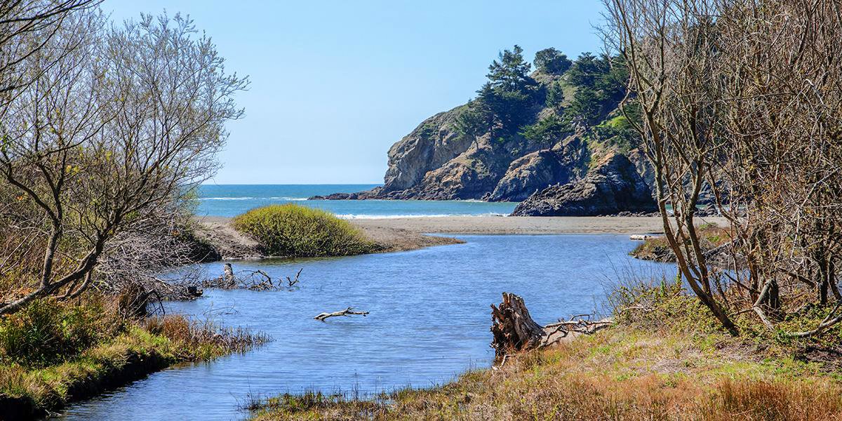
The watershed encompasses an area of less than 9 square miles. The furthest extent of the Redwood Creek Watershed in the north begins with Fern Creek at the top of the East Peak of Mt. Tamalpais and runs down along the ridgeline of Panoramic Hwy to Hwy 1 and Green Gulch to the south. As it flows southeast towards Muir Woods National Monument, Fern Creek is joined by Laguna Creek. At the confluence in Muir Woods with Rattlesnake Creek, Bootjack Creek, and Ben Johnson Creek, the tributaries become Redwood Creek. Redwood Creek continues to collect tributaries coming down from the ridgeline of Panoramic Highway below the community of Muir Woods Park and Muir Woods Road, then it turns to the southwest along Frank Valley Road where it picks up Kent Canyon Creek. As the creek jogs back along the valley floor to the southeast, it crosses under Highway 1 into the community of Muir Beach. There it collects Frank Valley Creek and then Green Gulch Creek before meandering southwest again into Big Lagoon at Muir Beach where it drains into the Pacific Ocean.
Redwood Creek is one of five global biodiversity “hot spots" recognized in the United States. Its location is also within Golden Gate Biosphere Reserve.
The Redwood Creek watershed contains a variety of habitat types including coastal chaparral, grassland, old-growth redwood forest, mixed hardwood forest, seasonal wetlands, and riparian woodlands. Special-status plants include Mt. Tamalpais manzanita, Tamalpais oak, Tiburon buckwheat, and the Mount Tamalpais jewel-flower. A large intermittently tidal lagoon occurred at the mouth of Redwood Creek before the land use changes that followed European colonization of the watershed. This lagoon once covered an area of approximately 25 acres. Only a remnant of the restored lagoon remains today.
Special-status species include Coho salmon, Steelhead trout, California red-legged frog, Monarch butterflies, Northwestern pond turtle, and Northern spotted owl. Redwood Creek was previously considered the southernmost stable population of Coho salmon. After their disappearance in 2007-2008, major efforts have been taking place to restore the natural flow and habitat in Redwood Creek and Big Lagoon and reestablish them.
Tennessee Valley and Rodeo Lagoon
The two southernmost coastal watersheds are Tennessee Valley and Rodeo Lagoon. Their location is north of Point Bonita and south of Muir Beach and Coyote Ridge. These watersheds flow through the lands of GGNRA and along the western slopes of the Marin Peninsula, backing up to the Richardson Bay Watershed on the eastern slopes.
Tennessee Valley Creek is fed by five intermittent tributaries collecting in the valley floor through the 2 square miles of the Tennessee Valley drainage. The Tennessee Valley Trailhead begins at the end of Tennessee Valley Road in Tamalpais Valley and the trail runs along the creek for the entire 1.7 miles where it flows into the Pacific Ocean at Tennessee Beach. The Tennessee Valley watershed is largely composed of grassland and coastal scrub habitats. It has a small freshwater marsh near the lower watershed. Similar habitat types occur within the Rodeo Lagoon watershed.
Rodeo Creek has a main stem and southern tributary that flow into Rodeo Lagoon near Fort Cronkhite and the Marine Mammal Center. The Lagoon drains an area of approximately 4 square miles. The main stem watershed boundary is delineated by the Miwok and Bobcat trails, and the southern tributary watershed is encompassed within the Rodeo Valley and SCA Trails and flows down to the southwest along Bunker Road where it joins with the main stem before flowing into Rodeo Lagoon. During winter storm events the sand bar is breached at Rodeo Beach, allowing the lagoon to flow into the ocean.
Rodeo Lagoon is an important aquatic resource for a variety of native fish and wildlife species including the Salt marsh common yellowthroat, Monarch butterfly, California brown pelican, Mission blue butterfly, Point Reyes jumping mouse, Tidewater goby, and Franciscan thistle.
Remember, storm drains connect streets to creeks. Simple changes can make a big impact. Southern Coastal Watershed is Ours to Protect.