
Your Ross Valley Watershed
The Ross Valley watershed is just under 29 square miles and stretches from the slopes of Mt. Tamalpais and White’s Hill through the communities of Fairfax, Sleepy Hollow, San Anselmo, Ross, Kentfield, Greenbrae, Larkspur, and Corte Madera before crossing under Hwy 101 to the San Francisco Bay at the Larkspur Ferry Terminal.
While Corte Madera Creek is the wider, mostly tidally influenced, main stem flowing through the valley floor and into the estuarial marshlands of the Ross Valley Watershed, it’s headwaters begin more than 12 miles from the bay, fed by the waters flowing from San Anselmo Creek. San Anselmo Creek flows east from the slopes of Happersberger Point above Cascade Canyon Open Space Preserve. San Anselmo Creek is first met by Cascade Creek from the north. Cascade Creek has its own tributary in Pine Mountain Creek and Cascade Falls is a short hike up Cascade Falls Trail from the confluence with San Anselmo Creek. Shortly after the creek is met by Carey Camp Creek from the west, just upstream from the Elliot Nature Preserve Trailhead at the end of Cascade Drive. The creek flows to the east along Cascade Drive down into the Town of Fairfax where it is joined by Wood Lane Creek from the southwest just before crossing under Bolinas Road. It is then met by Deer Park Creek from the south just after crossing under Creek Road. There are trails into Marin Municipal Water District Open Space at the ends of Wood Lane and Porteous Avenue following along both creeks!

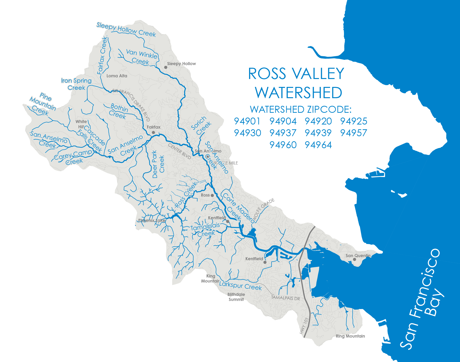
San Anselmo Creek is then joined by Fairfax Creek from the north behind Bridge Ct. Fairfax Creek begins at the top of the ridge in the Loma Alta Open Space Preserve where the 680 Trail crosses over the top from the Smith Ridge Fire Rd. As it reaches the bottom of the slope the creek follows along Baywood Canyon Road. Iron Spring Creek joins Fairfax Creek from White Hill to the west at the intersection of Baywood Canyon Rd. and Sir Francis Drake Blvd. The creek continues to follow along Sir Francis Drake Blvd. until it veers south and crosses under Olema Rd. It’s joined by Bothin Creek, which begins above the end of Bothin Rd., behind the Fairfax Library. From there the creek flows south along Arroyo Rd. then crosses under Spruce Rd. and Merwin Ave. before entering Peri Park Grove. It winds through the park and behind Fairfax Community Center, Fire Station 21, and the Fairfax Police Department before piping from Bolinas Rd. to its confluence with San Anselmo Creek.
The creek then flows southeast through Fairfax passing behind Fairfax Plaza. It follows along the south side of Center Blvd. into San Anselmo until crossing under at San Anselmo Ave. and curving around the backside of Archie Williams High School before passing under the Saunders Ave. where it’s joined by Sleepy Hollow Creek. Sleepy Hollow Creek drains the entirety of Sleepy Hollow and begins on the backside of the ridge from Fairfax Creek on the same 680 Trail coming over from the Loma Alta Open Space Preserve. The creek flows east down to San Domenico High School. From there it flows south under Van Winkle Drive where it’s joined from the west by Van Winkle Creek, which begins at the water storage tanks on the ridgeline in Loma Alta Open Space Preserve. The creek follows along Butterfield Rd. all the way down to Brookside Elementary School where it veers southeast, winding along Brookside Dr., then heading south under Sir Francis Drake Blvd. and through the Archie Williams High School campus. The Sleepy Hollow Creek subwatershed is mostly on private lands but there are access points for trails to Loma Alta, Terra Linda-Sleepy Hollow Ridge, and Terra Linda-Sleepy Hollow Northern Divide Open Space Preserves in the upper watershed.
San Anselmo Creek winds its way through the residential neighborhood and passes under Calumet Ave. and Nokomis Ave. bridges where it’s met by Sorich Creek. Sorich Creek begins in Sorich Park at the end of San Francisco Blvd. and flows down through the neighborhood before crossing the end of Los Angeles Blvd. and around the Log Cabin at Memorial Park. The creek is piped under the Red Hill Shopping Center and Sir Francis Drake Blvd., before daylighting again along Nokomis Ave. San Anselmo Creek then passes back under Center Ave. and into downtown San Anselmo and flowing through Creek Park. The creek follows along Sir Francis Drake Blvd. into Ross where it is joined by Ross Creek from the west to form Corte Madera Creek.
Ross Creek is fed by Phoenix Lake, but the upper watershed begins on the northeast slopes of Mt. Tamalpais on the backside of the ridge from Lake Lagunitas and Bon Tempe Lake. Phoenix Lake is fed by Bill Williams, Windy Ridge, and Eldridge Creeks from the south, and Phoenix and Lancer Creeks from the west. Below the dam Ross Creek flows northeast through Natalie Coffin Green Park and along Dibblee Rd. before crossing under Glenwood Ave. and circling behind The Branson School on its way under Shady Ln. and the confluence at Corte Madera Creek.
Corte Madera Creek continues alongside Sir Francis Drake Blvd through Ross. Behind Ross Common the creek changes to a trapezoidal concrete lined channel where it’s joined by Kittle Creek coming from the northwest. Kittle Creek begins at the top of Canyon Rd. It follows the road down and curves to continue down Laurel Canyon Rd. before turning south to flow through the Marin Art and Garden Center and under Sir Francis Drake Blvd. near Berry Ln. Reaching Kentfield Corte Madera Creek flows through the College of Marin Campus and around Kent Middle School. As the creek travels south behind the College of Marin sports fields, it returns to a natural channel and is joined by Murphy and Tamalpais Creeks from the west. Murphy Creek drains the hillside slope starting at Redwood Drive in Ross and crosses under Kent Ave. just north of Stadium Way in Kentfield, and Tamalpais Creek drains all of Kent Woodlands and crosses under Kent Ave. just north of Woodland Rd. Both are piped from Kent Ave. all the way to Corte Madera Creek.
As Corte Madera Creek rounds the bend between Kentfield to the north and Larkspur to the south, it’s met by McAllister and Wolfe Grade Creeks flowing along the west side the marshlands at Hal Brown Park. McAllister Creek runs along the west side of Laurel Grove Ave. and drains the slope areas along both sides of the road up to Makin Grade. At the bottom of the hill the creeks pipes under Laurel Grove Ave. and Sir Francis Drake Blvd. where it connects with Wolfe Grade Creek and daylights at the beginning of McAllister Ave. Wolfe Grade Creek begins east of the top of Wolfe Canyon Rd. and drains the area from Wolfe Grade to Los Cerros Dr. It runs down the east side of Wolfe Grade and crosses under at the bottom of the hill, continuing west in a pipe along Sir Francis Drake Blvd. to McAllister Ave. There the two daylighted creeks flow between the edge of the road and Bacich Elementary School until they veer around the back of the school and along the west side of marsh behind Hal Brown Park. After crossing under Bon Air Bridge, Corte Madera Creek curves along Boardwalk One and around Piper Park where it’s met by the side channel created by Larkspur Creek from the south and Greenbrae Creek from the north.
Larkspur Creek begins on the eastern slope of Mt. Tamalpais in the Baltimore Canyon Open Space Preserve, tucked between Blithedale Summit and King Mountain. The creek features the seasonal 30ft Dawn Falls that can be accessed via the Dawn Falls Trailhead at the end of Madrone Ave. As the creek reaches the city it follows along Madrone Ave. all the way to Dolliver Park where it crosses under Magnolia Ave. and then heads north, crossing under King St. behind the Larkspur Library. After crossing under Cane St. the creek turns sharply to the east, then north again running between Rose Ln. and the Larkspur Bike Path. After crossing under Doherty Dr. at the Central Marin Police Station, the creek jogs to the east to connect to the side channel between Piper Park and the west side of the Larkspur Marina neighborhood. Greenbrae Creek drains the Greenbrae hillside area between Los Cerros Dr. and Paseo Wy. Although it only has a small section of daylighted channel in the lower median section of Los Cerros Dr. before piping under Bretano Wy. and Sir Francis Drake Blvd. where it becomes an open channel flowing southeast behind the west end of the Bon Air Shopping Center, connecting to Corte Madera Creek at the end of S. Eliseo Dr.
The last tributary to join Corte Madera Creek is High Canal flowing in from Corte Madera to the south. There aren’t any high ridgelines above the upper sections of downtown Corte Madera to form any named creeks but there are some small ephemeral channels carrying storm flow from the hillside slopes above Corte Madera Ave. and Tamalpais Dr. into the town’s storm drain system which empty into both High and Low Canals. Both canals originate in Corte Madera Town Park. High Canal originates on the west side of the park next to Town Park Playground and Pixley Lagoon, and curves east along Pixley Ave. before heading north along Birch Ave., then under the Corte Madera-Larkspur Path all the way to the pump station/tide gates at Lucky Dr. next to Redwood High School. A pedestrian/bike path runs the entire length of High Canal. Low Canal starts alongside Corte Madera Dog Park and runs north along the eastern edge of the park before curving to the west into Lagoon 1. High Canal only contributes flow to Corte Madera Creek during the winter when runoff is flowing in. The rest of the year High Canal is mostly kept artificially full when the tide gates/pumps are closed to tidal influence. Similar to Larkspur Creek, High Canal connects to Corte Madera Creek via a side channel that runs along of the east side of the Larkspur Marina neighborhood.
Unlike many of the other watersheds in Marin that only have public access to the creeks in the upper watersheds or along the baylands, Corte Madera Creek has pedestrian paths that run most of the way alongside it from Hwy 101 in Greenbrae to downtown Ross, providing great views of the creek and Mt. Tamalpais! It is one of few streams flowing into San Francisco Bay with a steelhead trout (Oncorhynchus mykiss) population. The best spawning gravels are in Upper San Anselmo Creek, Ross Creek, and Sleepy Hollow Creek. Fairfax Creek has a total barrier to fish passage at its confluence with San Anselmo Creek. Larkspur Creek is rumored to have had steelhead long ago, and the occasional steelhead is still seen in Tamalpais Creek.
The main non-salmonid fish species in the Corte Madera Creek Watershed include the three-spined stickleback, California roach, several species of sculpin, and Sacramento sucker.
The creek hosts many protected species in addition to Steelhead trout, including at least 17 plants, Northern spotted owls, San Pablo song sparrow, Ridgway's rail and Black rail, Foothill Yellow-legged frog, and the Salt-marsh harvest mouse. The 1,000-acre Corte Madera Marsh Ecological Reserve is recognized as an Important Bird Area by the Audubon Society.
Remember, storm drains connect streets to creeks. Simple changes can make a big impact. Ross Valley Watershed is Ours to Protect.